Saturday, April 16, 2016
Balboa Southbound Front Lighthouse - Balboa, Panama
The Balboa Southbound Front Lighthouse sits on a square concrete base in the water of the channel just north of the Bridge of the Americas. It was a guide for southbound ship traffic leaving the Panama Canal and heading to the Pacific Ocean. It is approximately 4 km south of the Miraflores locks. The light is a 9 metre (30 foot) black concrete tower. This light was deactivated and replaced by a newer light a short distance north in the channel. It is believed it was deactivated at the time of the opening of the bridge in the 1960's. Photo taken in March 2016.


Gamboa Southbound Front Range Lighthouse - Gamboa, Panama
The Gamboa Southbound Front Range Lighthouse is located on the west side of the River Chagres at the start of the Gaillard (formerly Culebra) Cut section of the Panama Canal. It is just south of the town of Gamboa and north of the bridge that spans the Chagres River. The light was constructed between 1904 and 1914 during the construction of the canal. It was activated at the opening of the canal in 1914. The lighthouse is a 14 metre (45 foot) grey concrete tower. This light was deactivated (year unknown) and replaced by a newer light on a pole nearby. Sadly, it appears to be abandoned, not maintained and has been tagged with graffiti. Photos taken in March 2016.


Friday, April 15, 2016
Gamboa Northbound Rear Lighthouse - Gamboa, Panama
The Gamboa Northbound Rear Lighthouse is located along the Chagres River approximately 6 km (4 miles) west of the town of Gamboa, Panama. It marks the approach to Gatun Lake from the south as ships transit the Panama Canal. The lighthouse is an 18 metre (60 foot) tall concrete tower. It is painted white on the front side (unsure about the rear). As with other lighthouses along the route of the canal, it was constructed between 1904 and 1914 during the original construction of the canal and was activated in 1914. It remains an active light. Photos taken in March 2016 and the bottom photo shows its proximity to the Gamboa Northbound Front Lighthouse.


Gamboa Northbound Front Lighthouse - Gamboa, Panama
The Gamboa Northbound Front Lighthouse is located on the Chagres River approximately 6 km (4 miles) west of the town of Gamboa marking the northbound approach into Gatun lake on the Panama Canal transit. The light was constructed during the original construction of the Panama Canal (between 1904 and 1914) and activated in 1914. It remains an active light. The lighthouse is a 14 metre (45 foot) tall concrete tower painted white on the front and black on the back. The bottom photo shows its proximity to the Gamboa Northbound Rear Lighthouse. Photos taken in March 2016.


Gatun Northbound Rear Lighthouse - Gatun, Panama
The Gatun Northbound Rear Lighthouse is located at the Gatun Locks on the Panama Canal south of the city of Colon. It is the rear range light for ships approaching the locks from Gatun Lake to the south. The light is a 27 metre (89 foot) tall white concrete tower with a blue base. The light remains active. It was built during the original construction of the Panama Canal (between 1904 and 1914) and was activated in 1914. Photos taken in March 2016.


Atlantic Entrance Range Middle Lighthouse - Gatun, Panama
The Atlantic Entrance Range Middle Lighthouse is an active light located about 100 metres to the north east of the Gatun Locks, the first set of locks encountered when entering the Panama Canal from the Caribbean/Atlantic side. It is south of Limon Bay and the city of Colon, Panama. This light was constructed during the original construction of the Panama Canal (between 1904 and 1914) and activated in 1914. It is a 23 metre (75 foot) tall white concrete tower. Photos taken in March 2016.


Limón Bay East Breakwater Light - Colon, Panama
The Limon Bay East Breakwater Light is an active light found on a long breakwater that extends from the east side of Limon Bay. It is a 33 metre (108 foot) steel mast on a tripod with a concrete base. It has a green slatted day marker attached to it. It marks the east side of the Caribbean/Atlantic entrance to the Panama Canal. Photos taken in March 2016.


Limón Bay West Breakwater Light - Colon, Panama
The Limon Bay West Breakwater Light is an active light found on a long breakwater that extends from near the Toro Point Lighthouse on the west side of Limon Bay near Colon, Panama. This light is one of two breakwater lights that mark the Caribbean/Atlantic entrance to the Panama Canal. This light is a 31 metre (102 foot) steel mast on a tripod and cement base. It also has a slatted red day mark attached to it. Photos taken in March 2016.


Toro Point Lighthouse (Punta Toro) - Bahía Limón, Panama
The Toro Point (Punta Toro) Lighthouse is located on the west side of Limon Bay at the entrance to the Panama Canal in Panama. It is across from the city of Colon. It sits on the property that was Fort Sherman which was a U.S. Army base and their training centre for jungle warfare. The light sits at the base of the long west breakwater marking the entrance to the canal from the Caribbean/Atlantic side. The light was constructed in 1893 and is a 27.5 metre (90 foot) steel skeletal tower. The light is active. Unfortunately the photos are quite distant when taken in March 2016.


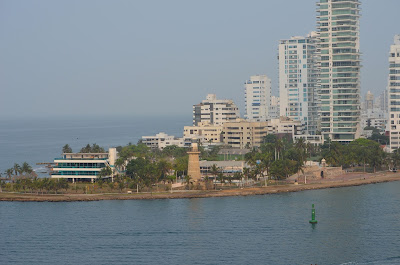
Castillo Grande Lighthouse - Cartagena, Columbia
The Castillo Grande Lighthouse sits at the end of a peninsula that extends from the Boca Grande area of Cartagena and marks the entrance to the main harbour at Cartagena. This lighthouse that was built in 1973 is a 22 metre (72 foot) concrete block tower. The light is active and sits on property owned by the Columbian navy. Photos taken in March 2016.



Saturday, July 4, 2015
New Book About Vancouver Island Lighthouses
A Flickr friend's photographs are featured in a new book about the lighthouses of Vancouver Island. The book is titled "To The Lighthouse - An Explorer's Guide To The Island Lighthouses of Southwestern B.C." Authors are John Walls and Peter Johnson and the photographs are by Richard Paddle. The book is published by Heritage House and is definitely something a lighthouse lover should have.


Wednesday, July 1, 2015
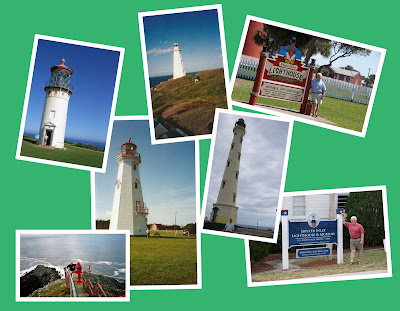
Enjoying My Hobby
As I have said before, visiting and photographing lighthouses is a great hobby and takes one to some beautiful spots that might otherwise get missed. Here are a few photos of me enjoying my hobby over the years....




Tuesday, June 30, 2015
Chatham Point Light Station, Inside Passage, British Columbia
The Chatham Point Light Station is located at the north end of Discovery Passage approximately 40 kilometres (25 miles) north from Campbell River, B.C. It is where Discovery Passage makes a sharp turn into Johnstone Strait. The station serves as a light station and a weather station and is staffed as of June 2015. The light itself is a white and green cylindrical steel tower on a concrete base and sits in the water off of the shore in front of the station. The station was originally established at this point in 1908. Photos (a bit distant) taken in June 2015.


Monday, June 29, 2015
Scarlett Point Light Station, Port Hardy, British Columbia
The Scarlett Point Light Station sits on the northeast point of Balaklava Island approximately 10 miles north of the town of Port Hardy on Vancouver Island. The station was originally established in 1905. The station remains active and as of 2015 was still a staffed light station. The current tower was erected in 1965 to replace the original tower. Photos (from a distance) taken in June 2015.


Pine Island Light Station, Pine Island, British Columbia
The Pine Island Light Station sits on the southwest side of Pine Island which is near the northeast tip of Vancouver Island north of the town of Port Hardy. The station was established in 1906 and has been active since that time. As of 2015 the station remains one of the few staffed light stations left in Canada. The current cylindrical steel tower was erected in 2001 to replace the original tower. Photo (from a distance) taken in June 2015.


Guard Island Lighthouse, Alaska
The Guard Island Lighthouse sits on one of two small islets at the north entrance to Tongass Narrows approximately 9 miles northwest of the city of Ketchikan, Alaska. The station was first established in 1904 and the current lighthouse building was built in 1924. The former keepers house and other buildings were demolished in 1973. The light is automated and the last keeper left the light in 1960. It is only accessible by boat. You can get close to the lighthouse by taking the Lighthouse, Totems and Eagles Excursion. Photos taken in June 2015.


Saturday, January 24, 2015
Sandy Point Lighthouse, Shelburne, Nova Scotia
In going through some old (pre-digital photography) albums, I came across this photo I took of the Sandy Point Lighthouse near Shelburne, Nova Scotia. It is located on the east side of the entrance to Shelburne Harbour on a concrete pier. It commenced operation in 1880 on a wooden pier which was later replaced by the concrete pier. It was manned until 1980 when it was automated. It was discontinued by the Coast Guard in 1996 and is now owned by the community of Sandy Point and serves as a tourist destination. The photo was taken in September 1998.

Friday, January 2, 2015
Fredericton Lighthouse, Fredericton, New Brunswick
The Fredericton Lighthouse (Lighthouse on the Green) is a faux lighthouse on the bank of the St. John River in Fredericton, New Brunswick. It was constructed in 1989 and has never served as an official aid to navigation. It is near the historic Garrison District in downtown Fredericton. Originally privately built, it has been operated by the Fredericton Tourism Bureau since 2002. It has served as a museum, gift shop and restaurant and has a popular observation platform. Photos taken in December 2014.


Subscribe to:
Posts (Atom)